

The 3D DSS project explores how digital tools can best support decision-makers in selecting optimal routes for new power transmission lines. The goal is to ensure that the chosen solution minimizes environmental and social impacts while offering acceptable alternatives to all involved stakeholders.
Our approach combines state-of-the-art Geographic Information Science (GIS), Multi-Criteria Decision Analysis (MCDA), game theory, and statistics to create a robust, transparent planning framework.
At the core of our work is the development of a flexible and interactive 3D Decision Support System (3D DSS). This tool is designed to enhance stakeholder communication, foster public acceptance, and streamline the planning process. By visualizing complex spatial data and trade-offs in 3D, the system helps reduce both planning time and costs—leading to more sustainable and broadly supported grid expansion projects.
Key findings
- Developed the 3D DSS — the first open-source tool for planning power transmission lines across all voltage levels with interactive 3D visualization
- Created a novel method for seamlessly combining overhead and underground transmission line sections within a single planning framework
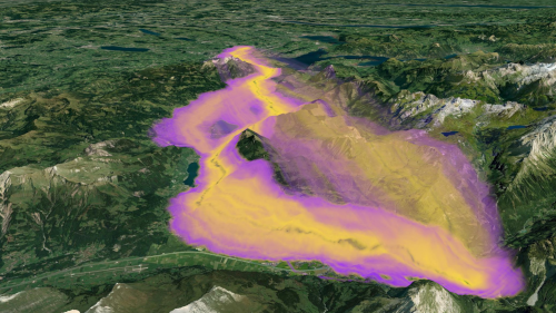
- Designed a fast algorithm for identifying multiple Pareto-optimal routing alternatives, enabling planners to focus on the most meaningful solutions
- Enhanced stakeholder engagement and transparency through interactive evaluation of user-defined routes and real-time visual feedback
- Validated the 3D DSS with extensive testing by transmission line experts and authority representatives, confirming its practical reliability for real-world planning

Project description
Project 1: Planning Overhead Lines with GIS
Defining the optimal path for transmission lines is time-consuming and often faces strong social opposition. This project develops an integrated 3D GIS web platform to support route planning, improve stakeholder communication, and reduce opposition. Enhanced 3D visualizations help stakeholders better understand the project’s impact on the surroundings.
Project 2: Planning Earth Cables with GIS
Geographic Information Systems (GIS) allow calculating and visualizing power line corridors in 3D. However, existing approaches are limited to overhead lines. The goal of this project is therefore to develop an integrative approach that models overhead lines and underground cables taking into account geological, infrastructural, ecological, as well as socio-economic aspects and to integrate the algorithm into an existing 3D web-GIS-platform.

Study areas
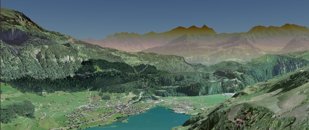
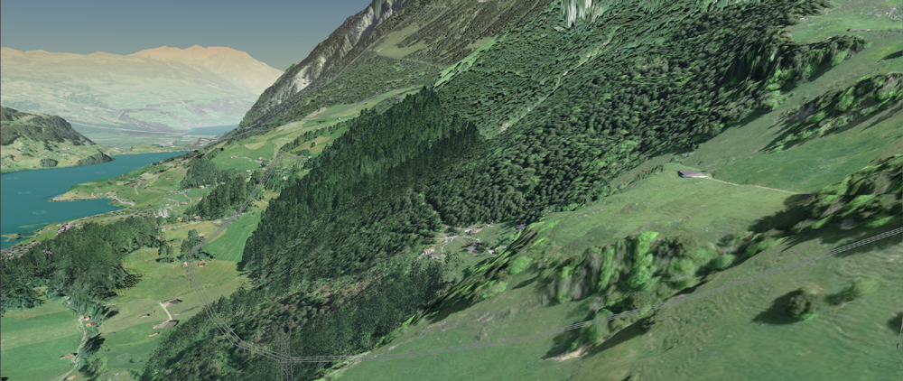
Innertkirchen–Mettlen
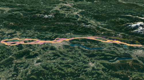
The region between Innertkirchen and Mettlen is located within the foothills of the Alps and the flatland of central Switzerland. Innertkirchen is located in the Bernese Oberland on 643 meters above sea level while Mettlen is located next to Lucerne on 419 meters above sea level. The line has to cross at least two valleys over a distance of approximately 60 kilometers.
Kärnten
The region between St. Job and Obersielach is located within the basin of Klagenfurt in Kärnten, Austria. St. Job is located next to Villach on 563 meters above sea level while Obersielach is located next to Völkermarkt on 504 meters above sea level. The line has to cross the basin on the foothills of the Alps over a distance of approximately 70 kilometers.
Publications
Peer-reviewed publications
Joram Schito, Daniele Moncecchi and Martin Raubal. Determining transmission line path alternatives using a valley-finding algorithm. Computers, Environment and Urban Systems 86:101571, 2021. DOI: 10.1016/j.compenvurbsys.2020.101571
Joram Schito. Realistic Modeling of Power Transmission Lines with Geographic Information Systems. Dissertation, ETH Zurich, Zurich (Switzerland), 2020. DOI: 10.3929/ethz-b-000454195
Joram Schito, Joshu Jullier and Martin Raubal. A framework for integrating stakeholder preferences when deciding on power transmission line corridors. EURO Journal on Decision Processes, Springer, vol. 7(3), pages 159-195, 2019. DOI: 10.1007/s40070-019-00100-w
Joram Schito, Ulrike Wissen Hayek and Martin Raubal. Enhanced multi criteria decision analysis for planning power transmission lines. GIScience Conference 2018, Melbourne, Australia. DOI: 10.1007/s40070-019-00100-w
Fabio Veronesi, Joram Schito, Stefano Grassi and Martin Raubal. Automatic selection of weights for GIS-based multicriteria decision analysis: site selection of transmission towers as a case study. Applied Geography 83:78–85, 2017.
Joram Schito. Modeling and optimizing transmission lines with GIS and Multi-Criteria Decision Analysis. it – Information Technology 59(1):1–9, 2017. DOI: 10.1515/itit-2016-0057
Other publications
Ulrike Wissen Hayek, Joram Schito, Orencio Robaina, Martin Raubal, Adrienne Grêt-Regamey. Modeling and Visualizing Earth Cable Paths in the Urban Underground. gis.Science (4):99–109, 2021.
Joram Schito and Martin Raubal. Automatisierte Planung von Hochspannungsleitungen mit dem 3D DSS. Geomatik Schweiz (10):12–15, 2020.
Joram Schito. Hochspannungsleitungen planen und deren Akzeptanz erhöhen–mit dem 3D Decision Support System der ETH Zürich. In Wissenschaftsdialog 2018 der Bundesnetzagentur.
Joram Schito, Ulrike Wissen Hayek and Martin Raubal. Ein 3D Decision Support System zur realistischen Planung von Hochspannungsleitungen. In EnInnov Energy for Future – Wege zur Klimaneutralität. 269–270.
Joram Schito, Ulrike Wissen Hayek and Martin Raubal. Ein 3D Decision Support System zur realistischen Planung von Hochspannungsleitungen. In EnInnov2020 – 16. Symposium Energieinnovation, Graz, Austria, 2020. ISBN 978-3-85125-734-2.
Joram Schito. Hochspannungsleitungen planen und deren Akzeptanz erhöhen–mit dem 3D Decision Support System der ETH Zürich. In Tagungsband des Wissenschaftsdialog 2018 der Bundesnetzagentur, Bonn, 2018. DOI: 10.3929/ethz-b-000377753
Thomas M Klein, Adrienne Grêt-Regamey, Martin Raubal and Joram Schito. Eine 3D entscheidungsunterstützende Plattform zur transparenten und nachhaltigen Planung von elektrischen Versorgungsnetzen. In Leitfaden 3D-GIS und Energie. Runder Tisch GIS e.V., 2015, pages 111–112.
Joram Schito and Stefano Grassi. Berechnung optimaler Pfade und Korridore für Hochspannungsleitungen. In Leitfaden 3D-GIS und Energie. Runder Tisch GIS e.V., 2015, pages 80–82.
Scientific reports
Joram Schito, Ulrike Wissen Hayek, Stefano Grassi, Philippe Bieri and Martin Raubal. Enhancing the 3D DSS for Supporting the Planning of Electric Power Systems: Integration of Underground Cables. Final Report Sl/501704-01, Swiss Federal Office of Energy, 2020.
Ulrike Wissen Hayek, Joram Schito, Stefano Grassi and Philippe Bieri. 3D DSS Schlussworkshop – Zusammenfassung. Workshop Evaluation, ETH Zürich, 2020.
Joram Schito and Ulrike Wissen Hayek. 3D Decision Support System (3D DSS) zur Unterstützung der Leitungsplanung. Technische Anleitung, ETH Zurich, 2020.
Martin Raubal, Joram Schito, Adrienne Grêt-Regamey and Ulrike Wissen Hayek. Einsatz von 3D GIS zur transparenten und nachhaltigen Planung von elektrischen Versorgungsnetzen. Schlussbericht SI/507073-01, Bundesamt für Energie BFE, 2017.
Ulrike Wissen Hayek and Joram Schito. Decision Support System (3D DSS) zur Unterstützung der Planung von Übertragungsleitungen: Auswertung der Nutzerevaluation. ETH Zürich, 2017.
Master theses
Daniele Moncecchi. Exploiting Valley Extraction Algorithms for Improving Power Transmission Line Routing. Master Thesis, Politecnico di Milano, Milano (Italy), 2020.
Konstantinos Schoinas. Planning Earth Cables with GIS. Master Thesis, ETH Zurich, Zurich (Switzerland), 2018.
Nadine Piveteau. A Novel Approach to the Routing Problem of Overhead Transmission Lines. Master Thesis, University of Zurich, Zurich (Switzerland), 2017.
Julia Song-Zinggeler. Usability Testing of Decision-Support System for Power Line Planning – Differences between user groups and overall usability. Master Thesis, ETH Zurich, Zurich (Switzerland), 2016.
Posters
Daniel Moncecchi and Joram Schito. What is a valley? A procedure that helps determining route alternatives for power transmission lines. SCCER FURIES – 6th Annual Conference, Lausanne (Switzerland), 2019.
Joram Schito and Ulrike Wissen Hayek. 3D Decision Support System (3D DSS) for Transmission Line Planning: Latest Results. SCCER FURIES – 6th Annual Conference, Lausanne (Switzerland), 2019.
Joram Schito and Martin Raubal. Planning transmission lines upside down: How earth cables are combined with overhead lines. SCCER FURIES – 5th Annual Conference, Lausanne (Switzerland), 2018.
René Buffat, Joram Schito and Martin Raubal. Spatio-temporal modelling of renewable energy in Switzerland using GIS. SCCER FURIES – 4th Annual Conference, Lausanne (Switzerland), 2017.
Joram Schito. Modeling transmission lines by considering proximity effects and multiple protected areas. PhD Workshop “Energy Informatics”, Klagenfurt (Austria), 2016.
Joram Schito and Martin Raubal. Application of 3D Geographic Information Systems for the planning of electric power systems. SCCER FURIES – 3rd Annual Conference, Lausanne (Switzerland), 2016.
Fabio Veronesi, Joram Schito, Stefano Grassi and Martin Raubal. Planning Transmission Lines for Future Network Expansion. SCCER FURIES – 3rd Annual Conference, Lausanne (Switzerland), 2016.
Fabio Veronesi, Stefano Grassi, Joram Schito and Martin Raubal. The Importance of Geographic Information Systems for Planning Renewable Facilities. SCCER FURIES – 2nd Annual Conference, Lausanne (Switzerland), 2015.
Stefano Grassi, Fabio Veronesi, Joram Schito and Martin Raubal. An integrated GIS-based method for planning power lines targeting interactive public participation. SCCER FURIES – 1st Annual Conference, Lausanne (Switzerland), 2014.